Lower Mills, 1793
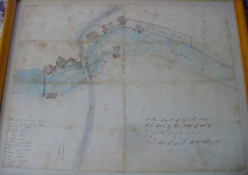
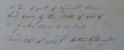
This 1793 plan of Lower Mills, Dorchester, was drawn by Mather Withington, a frequent surveyor of the area. For example, he surveyed for the deed of the Suffolk Resolves House from Daniel Thomas Vose to Clarissa Holbrook (document at Massachusetts Historical Society, call# Ms.N-1356). Though this map he titled, "Plan of part of the Neponset River" (see below for a close-up of the title block), his survey work here seems focused on "Mr. John Preston's Land and Mills," the lot boldly demarcated in the upper right.
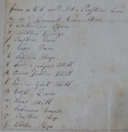
Happily, though, Withington labeled all the other buildings on the map with a legend (below left for a close-up), noting "(c) Mr. Daniel Voses Store, (d) watering place, (e) Milton Bridge, (f) Prestons Dam, (g) Voses Dam, (h) Leeds's Shops, (i) Leeds's paper Mill, (k) Pierces fulling Mill, (l) Leeds's Grist Mill, (m) Mill Dam, (n) Sons[?] Mill, (o) Robinsons House, (p) Prestons Shop, (q) Blakes Shop." Combined with the 18th-century custom of showing buildings' elevations instead of footprints, these labels make this a remarkable document.
Click on the images below to see the map's legend (left) and title block (right).