|
|
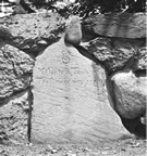
Milestones in Milton Before the introduction of the steam railway it was the custom in the new world, as in the old, to travel by stagecoach or private carriage on the roads which connected the towns and villages which lay scattered on the route. At intervals on these roads could be seen stone posts suitably inscribed, which were called milestones. They were a welcome sight to travelers, when beginning in gay mood a day’s journey; a more welcome sight at nightfall when one was found to be near a hospitable tavern where food and shelter were ready for tired traveler and more tired beast... It was customary in tavern days for a landlord to locate at a mile post on a highway, and fortunate indeed was he whose hostelry was placed at the end of a day’s journey, for this ensured him a steady and profitable business. We can see in imagination the rotund figure of “mine host” as he hastens to his front door on the arrival of the evening coach, joyfully rubbing his hands together at the prospect of a good night’s trade. Landlords were permitted by authority to place milestones in front of their taverns at their own expense and were even allowed to so place such stones if the house were located on one side or the other of the proper marking-places. These private stones bore the initials of the landlord in addition to the distance inscription, and were formerly many in number… In these opening years of the twentieth century, as we travel through some of the highways and byways of Greater Boston, by trolley car, automobile or “shank mare,” we see scattered along the roadside many milestones which have come down to us from the days of which we have been speaking. They are zealously guarded to-day by the antiquarians who delight in the study of the past, although in a practical way the present also claims their activity. We should know something of the men to whom the people of Boston and its vicinity were indebted for placing so many milestones… Descending the slope to the Neponset River, the picture of the valley and the hills beyond gladdening our eyes, we cross the river at Dorchester Lower Mills, and find ourselves in Milton, one of the fairest towns in the Commonwealth. Continuing on Adams street in that town, we find the last of the [Governor] Belcher stones set in the front wall of Hutchinson Field, a metropolitan reservation. It is inscribed — Milton, one of the fairest towns in the Commonwealth.
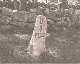
As we stand in front of this stone on the summit of Milton Hill and look on the beautiful picture embracing the Blue Hills and the wide expanse of Boston Harbor, we recall the three royal governors who traveled by coach and four the lower road to Dorchester in the eighteenth century. Time and again have Governor Belcher and Governor Hutchinson counted the milestones on this road as they journeyed to and fro between the Boston town house and their estates in Milton… The line of milestones which were placed on the Upper Road to Dorchester, and extended through Milton to Quincy, should be considered next. These stones are shown on an original plan which is preserved in the Massachusetts Archives. It is entitled “Boston Town House to the ten-mile stones in Quincy measures 10 ¾ miles plus 1 rod. The Upper Road as travelled,” and was drawn in 1802 by William Traylor of Boston, Surveyor. The total distance 10 ¾ miles plus 1 rod, indicates that the stones were not placed in their proper locations, and furthermore the distance between them vary from 78 to 120 chains. On Adams street, Milton, which was laid out as early as 1654, we see near the railroad station the stone, which is inscribed— B
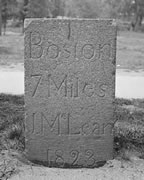
On the broad boulevard which we now call Blue Hill avenue, and which was called Brush Hill Turnpike from 1805 to 1870, we find the [John] McLean milestones, which were placed in 1823. They are six in number, are constructed of hammered granite of uniform size, and the inscriptions on them are similar, with the exception of the numeral indicating the distance from Boston…The seven-mile stone is passed as one enters the town of Milton.
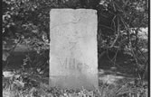
Continuing, we find the three remaining McLean stones in Milton. The eight-mile stone is about a quarter of a mile south of Robbins street and the nine-mile stone is at Atherton street, and the ten-mile stone is safely set in the stone wall of a private residence not far from the boundary line between Milton and Canton. NOTE: Many of these milestones are still found in Milton today, as well as at least two additional ones not mentioned by the author — the 1776 milestone of I. Gulliver (incorporated into a wall at 741 Canton Avenue) near Gile Road and this milestone for the old Blue Hill Turnpike located on Randolph Avenue (as the former turnpike is known today) at the intersection of School Street. Happy Hunting!
The above article is an excerpt taken from MILESTONES IN AND NEAR BOSTON by Charles F. Read published in The Magazine of History with Notes and Queries, Vol. X, July-December 1909.
|